


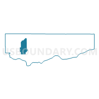
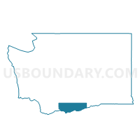
Appleton Voting District, Klickitat County, Washington
About
Outline

Summary
| Unique Area Identifier | 687410 |
| Name | Appleton Voting District |
| County | Klickitat County |
| State | Washington |
| Area (square miles) | 70.32 |
| Land Area (square miles) | 70.32 |
| Water Area (square miles) | 0.00 |
| % of Land Area | 100.00 |
| % of Water Area | 0.00 |
| Latitude of the Internal Point | 45.86342250 |
| Longtitude of the Internal Point | -121.25014790 |
Maps

Graphs
Select a template below for downloading or customizing gragh for Appleton Voting District, Klickitat County, Washington


Neighbors
Neighoring Voting District (by Name) Neighboring Voting District on the Map
- East Klickitat Voting District, Klickitat County, WA
- Glenwood Voting District, Klickitat County, WA
- Lyle Voting District, Klickitat County, WA
- Mt Brook Voting District, Klickitat County, WA
- West Klickitat Voting District, Klickitat County, WA
Top 10 Neighboring County Subdivision (by Population) Neighboring County Subdivision on the Map
- White Salmon CCD, Klickitat County, WA (7,769)
- Dallesport-Klickitat CCD, Klickitat County, WA (4,224)
- Yakama Nation Reservation CCD, Klickitat County, WA (453)
Top 10 Neighboring Unified School District (by Population) Neighboring Unified School District on the Map
- White Salmon Valley School District, WA (7,849)
- Lyle School District, WA (2,809)
- Klickitat School District, WA (592)
- Glenwood School District, WA (457)
Top 10 Neighboring State Legislative District Lower Chamber (by Population) Neighboring State Legislative District Lower Chamber on the Map
Top 10 Neighboring State Legislative District Upper Chamber (by Population) Neighboring State Legislative District Upper Chamber on the Map
Top 10 Neighboring 111th Congressional District (by Population) Neighboring 111th Congressional District on the Map
Top 10 Neighboring Census Tract (by Population) Neighboring Census Tract on the Map
- Census Tract 9501, Klickitat County, WA (8,325)
- Census Tract 9503, Klickitat County, WA (7,769)
- Census Tract 9502, Klickitat County, WA (4,224)